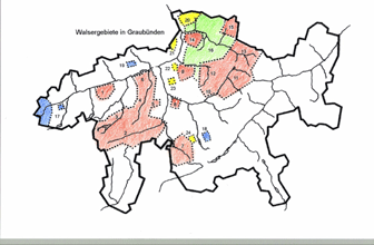
Walser Areas in Graubünden
The earliest documents, Erblenhensbriefe (Loan letters), which were issued to settlers by the Freiherrn (Barons) von Saxmisox and the Freiherrn von Vaz originate from Rheinwald (1286, occupied from 1274 according to documentation) and from Davos (1289). From these main colonies they spread into the neighbouring "Talschaften" (Valley communties): from Hinterrhein to Vals, Safien and eventually from here onwards to Avers and Mutten, from Davos to Klosters and through Prättigau up to Schiers with the high settlement St. Antönien, Furna and Valzeina on the valley side as well as into neighbouring Schanfigg up to Churwalden and Parpan.
Map of the Walser Areas (M. Hunger)

Key to the Map:
Today’s Walser areas in Graubünden (Red):
1 Obersaxen
2 Rheinwald
3 Vals - St. Martin
4 Safien - Tenna
5 Tschappina
6 Versam - Valendas
7 Avers
8 Mutten
9 Churwaldnertal - Praden
10 Schmitten - Wiesen
11 Davos
12 Langwies - Arosa
13 Klosters
14 Furna - Danusa - Valzeina - Says
15 St. Antönien
16 Walser German dialect in the early Roman speaking Prättigau and Schanfigg (Green)
Today Romanised (Blue):
17 Tavetsch - Mompé - Medel
18 Flix
19 Fidaz - Scheia
No longer inhabited or another German dialect (Yellow):
20 Stürvis - Guscha
21 Batänja - Mastrilserberg
22 Juchs
23 Schall
24 Val Faller - Sblox
Link Walservereinigung Graubünden: www.walserverein-gr.ch


